Dream – Art and Culture of Burning Man
Reading Time: < 1 minute
Plague inc is a game that is available on multiple platforms. These are pc, android, ios and windows phone. The version I played was on android. If you want to watch someone play the game you can watch this series:
I was at the first general Staff Meeting for the UNAIDS program a few years ago and more recently I was at the World Health organisation during the SARS crisis helping with Virtual Press conferences. During these two weeks I learned about the language used when discussing epidemics and how to mitigate the threat they posed.
During and after the Ebola crisis I was able to go to two or three conferences discussing how best to prepare future responses as well as to discuss what systematic weaknesses there were and how best to address them to deal properly with a future epidemic.
Plague inc is a real time decision based game. There are four tabs.
Overview provides you with an overview of air and sea transportTransmission: you can decide whether it is spread by air, water, blood, animals or birds. Symptons: You can decide how it affects people, whether through coughing, fever or other forms of discomfort. Abilities: You can develop, cold, heat, drug and bacterial resistance.
The game is an opportunity for people who do not live a 20 minute drive from the World Health Organisation and other UN organisations to learn more about the terminology of diseases as well as the factors that can make it more or less virulent and how best to counteract the threat.
In the game you may spend two or three years spreading a disease but in the real world diseases can spread over decades or even centuries. Look at Polio for example. Within the last two weeks we saw this headline Only complacency can stop Nigeria – and Africa – from finally conquering polio. For context UNICEF has a fact sheet about Polio eradication milestones. The Virus was first described by Michael Underwood in 1789, it was theorised as contagious in 1840 and in 1907 Dr Ivar Wickman categorised the different strains. It was first hypothesised that Polio was caused by a virus by Karl Lendensteiner in 1908. You can read more details in your own free time but the first vaccinations in Europe started in 1955 in Denmark. It is in 1988 that the World Health Assembly, the World Health Organisation yearly conference, adopted a resolution to eradicate Poliomyelitis by the year 2000. This goal was not reached due to various factors but finally in 2016 it looks as though the disease is ever closer to being eradicated.
Polio type 2 virus destroyed as strain no longer in Kenya
The Global Certification Commission verified that the type 2 virus had been eradicated globally in September last year. This means Kenya is polio-free as the last case was reported in 2013.
Whilst games like Plague Inc. can introduce us to the terminology used in the game we can also benefit from reading about real world epidemics, pandemics, plagues and more. I remember watching a documentary a few months ago that showed that thanks to the Plague in the Middle Ages in Europe serfs benefited as they were less numerous. It meant that they could finally pressure land lords to provide them with better working conditions and more freedom. Games are interesting but with the complement of history we see that reality is even more interesting.
![]() Google latitude is the perfect tool for anyone that works and has a life where logging into locations would be an unsightly thing to do. By that I mean that you can’t arrive at work and log into the location. It gives colleagues the impression you are not serious about your work.
Google latitude is the perfect tool for anyone that works and has a life where logging into locations would be an unsightly thing to do. By that I mean that you can’t arrive at work and log into the location. It gives colleagues the impression you are not serious about your work.
Now take this same situation in a social context. You go hiking and the people around you are not necessarily as passionate about technology. They’re walking around with paper maps after all.
That’s where Google latitude comes into it’s own. Location is tracked 24 hours a day, 7 days a week every single day that your device is on.
Why am I doing this? Am I not mad? Do I not have this location information to hide, and no shame? Well of course I have things to hide and shame but with this network only your closest friends can see where you are. And they only know your current location, not your previous locations.
That’s where the service differs from foursquare, gowalla, yelp and all the others. Your location history is private. Only you have access to it.
Then why use it in the first place? Well that’s simple. It’s a lifelog that’s not broadcast. You can keep track of how much time you’ve spent at home, at work and out socialising. Once a week I get to find out whether I was at work for more than fifty hours, whether I was at home for too many hours. More importantly i get to see whether I should not be a little more active in going out, from a personal life point of view. That’s where I’m lacking at the moment. Google latitude’s dashboard will help change that.
Now, how could it improve? First of all automatic location check in. If I’m by starbucks in Geneva airport log me in if I’m seeing that network more than ten minutes. If I’m at the apple store for that amount of time log me in there. If I’m at a bar and I lose signal in that region due to poor network coverage then assume I’m in that bar.
By being automatic and private location information could be quite a bit more interesting. More to the point that data is being collected anyway by mobile operators so why not take advantage of this?
I believe this to be the future of mobile geo-location. With more android phones out there and more devices capable of multitasking this could easily become the norm.

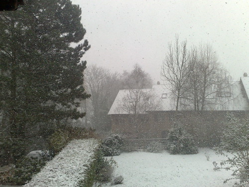
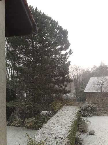
Today’s topic is quietness. As the weather was bad, and as there is no reason to leave the home unless you have to work, or to go for a walk everywhere was quiet. The roads were quiet, with few cars, the paths between fields were quiet. Even the motorway was quiet, as you can tell from the image above. It took just seconds for traffic to be rare enough for me to take this image.
On a normal weekend, you’d have hundreds of cars on this stretch of road. People would either be coming back from the mountains or commuting along this stretch of motorway to cross Switzerland.
Walking outdoors was pleasant because there were no people to avoid. It was unpleasant because today has been cold, windy and grey. That’s why no pedestrians were out. Even the dog walkers were home.
It might finally be the right time to start taking interesting pictures of deserted streets.
Today I was pleasantly surprised after racketing in the mountains to discover that my phone’s battery had not depleted. I was using sportstracker for over two hours and some charge was still left after an hour and a half. There was so much battery left in fact I went for nine more kilometers of walking and still the battery is healthy.
That’s not the only thing that’s improved. Now you have maps. You can’t move around the map except by changing geographic location but you can see the roads around you and more. It’s much simpler than google maps but then again there’s no need for such accuracy anyway.
Now I can spend half a day walking and still have enough power to be tracked the whole way. I know, half a day isn’t that long. Still better than an hour or two though.
Last night I recovered my N97 after lending it to a friend for a few days and he told me it was too complicated to use, which I do agree with, after seeing how easy the 3gs is, but that’s not the point of this post. Turn by turn navigation is.
For those of you who know me you’ll have heard that I’ve used the N95, N97 and Iphone for navigation and each has it’s strengths and weaknesses. Mainly the biggest weakness is having to wait until you’re stopped at a traffic light before checking whether you were going the right way or not. That has now changed.
Nokia have recently come out with an excellent, yes, that’s my opinion, add on to the maps software that provides turn by turn navigation with a choice of hundreds of voices. That’s what makes the Nokia N97 such a great, although expensive GPS. You select the voice, in my case female Canadian french, and she will tell you which way to go. She will tell you when you’re at a roundabout, whether to go right or left and more. Best of all her voice will allow you to keep your eyes on the road.
If you’re travelling with a fellow geek who can play with the phone whilst you’re driving then they will notice the counting down, telling you how far you are from the next change in direction, show a map of the route as a forerunner to the actual journey or even a map of the complete journey.
From what I’ve described above you see that the N97 behaves just like a dedicated navigation GPS that’s constantly online. As a result you get traffic information telling you what to look out for. It’s a beautiful piece of software and I’d love to go on a road trip to test it.
I’m in favour of this in car navigation. If you buy a GPS you’d pay 300-400CHF in some cases, several hundred CHF for the Iphone tom-tom app, or you could get it for free with your N97. The choice is yours. I’m very happy with how well it performed.